
Description
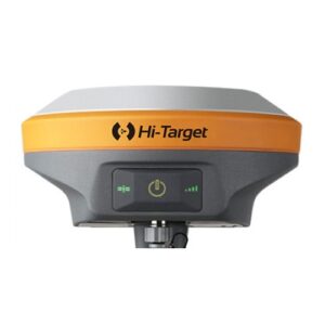
GPS Geodetic CHCNAV i83
Smart and Versatile IMU-RTK GNSS receiver for even intuitive surveying
Fitur CHCNAV i83
- PENERIMA GNSS IMU-RTK yang CERDAS DAN SERBAGUNA
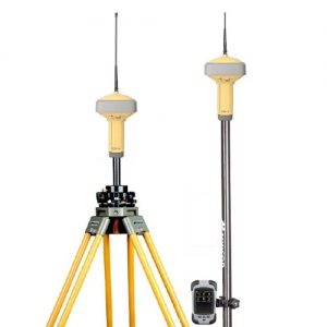
- SURVEI & TEKNIK
- DILUAR SURVEI GNSS RTK
- Didukung oleh GNSS 1408 saluran dan teknologi iStar
- KONEKTIVITAS YANG LEBIH CERDAS DARI SEBELUMNYA
- Penerima GNSS universal yang tak tertandingi
- DIRANCANG UNTUK PENGGUNAAN LAPANGAN
- 34 jam dengan sekali pengisian daya untuk memastikan pengoperasian saat Anda membutuhkannya
- ALAT SURVEI GNSS UNTUK SEMUA
- Survei IMU-RTK yang efisien menjadi mudah
Specifications GPS Geodetic CHCNAV i83 IMU-RTK GNSS
| GNSS Performance | Communication | |||||
| Channels | 1408 channels | SIM Card Type (optional) | Nano-SIM card | |||
| GPS | L1C, A, L2C, L2P(Y), L5 | Network modem (optional) | Integrated 4G modem. | |||
| GLONASS | L1, L2, L3* | LTE(FDD): | ||||
| Galileo | E1, E5a, E5b, E6* | B1,B2,B3,B4,B5,B7,B8,B20 | ||||
| BeiDou | B1I, B2I, B3I, B1C, B2a, B2b | DC-HSPA+/HSPA+/HSPA/UMTS: | ||||
| QZSS | L1, L2, L5, L6* | B1, B2, B5, B8 | ||||
| NavIC/ IRNSS | L5* | EDGE/GPRS/GSM | ||||
| PPP | B2b-PPP | 850/900/1800/1900 MHz | ||||
| SBAS | L1, L5 | Wi-Fi | 802.11 b/g/n, access point mode | |||
| Bluetooth | V 4.2 | |||||
| GNSS Accuracies | Ports | 1 x 7-pin LEMO port (RS-232) | ||||
| Real time kinematics (RTK) |
Horizontal: 8 mm + 1 ppm RMS | 1 x USB Type-C port | ||||
| Vertical: 15 mm + 1 ppm RMS | (external power, data download, | |||||
| Initialization time: <10 s | firmware update) | |||||
| Initialization reliability: >99.9% | 1 x UHF antenna port | |||||
| Post-processing kinematics (PPK) |
Horizontal: 3 mm + 1 ppm RMS | (TNC female) | ||||
| Vertical: 5 mm + 1 ppm RMS | UHF radio (optional) | Standard Internal Rx/Tx: | ||||
| High-precision static | Horizontal: 2.5 mm + 0.1 ppm RMS | 410 – 470 MHz | ||||
| Vertical: 3.5 mm + 0.4 ppm RMS | Transmit Power: 0.5 W to 2 W | |||||
| Static and rapid static | Horizontal: 2.5 mm + 0.5 ppm RMS | Protocol: CHC, Transparent, | ||||
| Vertical: 5 mm + 0.5 ppm RMS | TT450, Satel | |||||
| Code differential | Horizontal: 0.4 m RMS | Link rate: 9,600 bps to 19,200 bps | ||||
| Vertical: 0.8 m RMS | Range: Typical 3 km to 5 km, up | |||||
| Autonomous | Horizontal: 1.5 m RMS | to 15 km with optimal conditions | ||||
| Vertical: 2.5 m RMS | Data formats | RTCM 2.x, RTCM 3.x, | ||||
| Positioning rate Time to first fix |
1 Hz, 5 Hz, 10 Hz and 50 Hz | CMR input / output | ||||
| Cold start: < 45 s | HCN, HRC, RINEX 2.11, 3.02 | |||||
| Hot start: < 10 s | NMEA 0183 output | |||||
| Signal re-acquisition: < 1 s | NTRIP Client, NTRIP Caster | |||||
| IMU update rate | 200 Hz | Data storage | 8 GB internal memory | |||
| Tilt angle | 0~60° | |||||
| RTK tilt-compensated | Additional horizontal pole-tilt | Electrical | ||||
| uncertainty typically less than | Power consumption | Typical 2.8 W | ||||
| 8 mm + 0.7 mm/° tilt | (depending on user settings) | |||||
| Li-ion battery capacity | Built-in non-removable battery | |||||
| Certifications | 9,600 mAh, 7.4 V | |||||
| CE Mark; FCC Part 15 Subpart B Class B; | Operating time on internal battery |
UHF/ 4G RTK Rover: up to 34 h | ||||
| NGS Antenna Calibration; MIL-STD-810H, method 514.8 | UHF RTK Base: up to 16 h | |||||
| Static: up to 36 h | ||||||
| External power input | 9 V DC to 28 V DC | |||||
Paket termasuk:

Reviews
There are no reviews yet.