Description
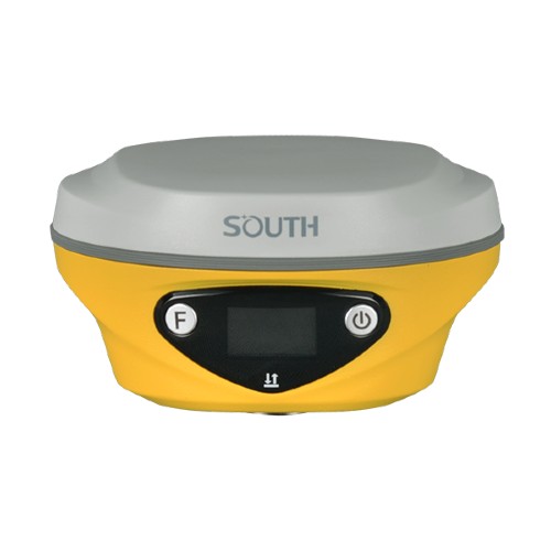
South ALPS1 adalah jenis receiver GPS yang relative sangat canggih dan pastinya memberikan data yang paling akurat. ALPS1 ini umumnya digunakan untuk project aplikasi yang menuntut ketelitian yang tinggi.
Fitur ALPS1
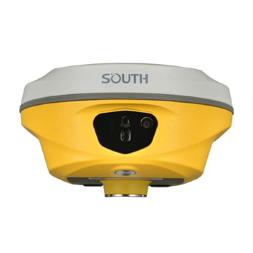
- ALPS1 memungkinkan Anda mengambil foto atau video secara langsung, memperoleh koordinat untuk ratusan titik dalam hitungan menit.
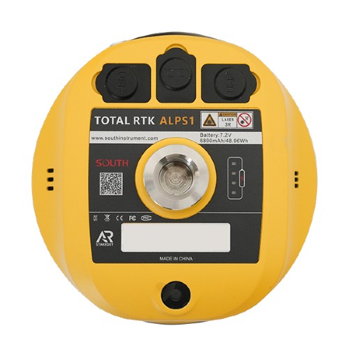
- Dengan pengukuran laser, ALPS1 memiliki jangkauan kerja yang lebih luas, sehingga memungkinkan pengukuran jarak jauh di area dengan kualitas sinyal GNSS.
- Data gambar, yang disimpan untuk jangka waktu lama, dapat digunakan kembali kapan saja.
- Pengukuran laser memungkinkan surveyor untuk mengumpulkan titik target di lingkungan yang gelap seperti malam hari atau lingkungan semi-dalam ruangan. Alat ini juga dapat mengukur jarak di dalam ruangan.
- Pemotretan Video memungkinkan surveyor untuk mengukur titik dari jarak jauh hingga 10 meter atau lebih (15 m dalam kondisi ideal), sehingga tidak perlu mendekati setiap titik secara fisik.
- Pengukuran Laser memungkinkan pengguna untuk melakukan pengukuran tanpa kontak yang sangat cepat saat ruang geraknya sangat terbatas, seperti gang sempit.
- Pemotretan Video dan Pengukuran Laser membantu pengguna mengurangi risiko saat melakukan survei di dekat area berbahaya, seperti jalan raya dan laut atau danau yang ramai, sehingga memastikan keselamatan surveyor.
Specification South ALPS1 Total RTK Multiply the Power
| GNSS Features | Channels | 1698 | ||
| GPS | L1C, L1C/A, L2C, L2P(Y), L5 | |||
| GLONASS | G1, G2, G3 | |||
| BDS | B1I, B2I, B3I, B1C, B2a, B2b | |||
| GALILEOS | E1, E5a, E5b, E6, AltBOC* | |||
| SBAS | L1* | |||
| SBAS | L5* | |||
| QZSS | L1, L2C, L5* | |||
| MSS L-Band | BDS-PPP, GALILEO-HAS | |||
| Positioning Output Rate | 1Hz~20Hz | |||
| Initialization Time | < 10s | |||
| Initialization Time | > 99.99% | |||
| Positioning Precision | Code differential GNSS positioning | Horizontal: 0.25 m + 1 ppm RMS | ||
| Vertical: 0.50 m + 1 ppm RMS | ||||
| GNSS Static | Horizontal: 2.5 mm + 0.5 ppm RMS | |||
| Vertical: 3.5 mm + 0.5 ppm RMS | ||||
| Static (Long Observation) | Horizontal: 2.5 mm + 0.1 ppm RMS | |||
| Vertical: 3 mm + 0.4 ppm RMS | ||||
| Rapid Static | Horizontal: 2.5 mm + 0.5 ppm RMS | |||
| Vertical: 5 mm + 0.5 ppm RMS | ||||
| PPK | Horizontal: 3 mm + 1 ppm RMS | |||
| Vertical: 5 mm + 1 ppm RMS | ||||
| RTK(UHF) | Horizontal: 8 mm + 1 ppm RMS | |||
| Vertical: 15 mm + 1 ppm RMS | ||||
| RTK(NTRIP) | Horizontal: 8 mm + 0.5 ppm RMS | |||
| Vertical: 15 mm + 0.5 ppm RMS | ||||
| SBAS Positioning | Typically<5m 3DRMS | |||
| RTK Initialization Time | 2~8s | |||
| IMU Accuracy | 8mm+0.7 mm/°tilt | |||
| IMU Tilt Angle | Optimal accuracy within 60° | |||
| Hardware Performance | Dimension | 134mm(φ)×79mm(H) | ||
| Weight | 860g (battery included) | |||
| Material | Magnesium aluminum alloy shell | |||
| Operating Temperature | -45℃~+75℃ | |||
| Storage Temperature | -55℃~+85℃ | |||
| Humidity | 100% Non-condensing | |||
| Waterproof/Dustproof | IP68 standard | |||
| Shock/Vibration | Withstand 2 meters pole drop onto the cement ground naturally | |||
| Power Supply | 6-28V DC, overvoltage protection | |||
| Battery | Inbuilt 7.4v 6800mAh rechargeable Lithiumion battery | |||
| Battery Life*1 | 25h (static) | |||
| 20h (rover mode, optimal condition) | ||||
| Communications | I/O Port | 5-PIN LEMO interface (external power port + RS232) | ||
| Type-C interface (charge+OTG+Ethernet) | ||||
| UHF antenna interface | ||||
| Internal UHF | 2W Radio Tx&Rx | |||
| Frequency Range | 410-470MHz | |||
| Communication Protocol | Farlink, Trimtalk, SOUTH | |||
| Communication Range | Typically 8-10km with Farlink protocol, (12-15km in optimal condition) | |||
| Bluetooth | Bluetooth 5.0, Bluetooth 3.0/4.2 standard, | |||
| Bluetooth 2.1 + EDR | ||||
| NFC Communication | Support | |||
| Modem | 802.11 b/g/n standard | |||
| Data Storage/Transmission | Storage | 16GB SSD internal storage | ||
| Support automatic cycling storage | ||||
| Support external USB storage (OTG) | ||||
| The customizable sample interval is up to 20Hz | ||||
| Data Transmission | Plug and play mode of USB data transmission | |||
| Supports FTP/HTTP data download | ||||
| Data Format | Static data format: STH, Rinex2.01, Rinex3.02, etc. | |||
| Differential data format: RTCM 2.1, RTCM 2.3, RTCM 3.0, RTCM 3.1, RTCM 3.2 | ||||
| GPS output data format: NMEA 0183, PJK plane coordinate, Binary code | ||||
| Support: VRS, FKP, MAC, fully support NTRIP protocol | ||||
| Sensors | IMU | Built-in IMU module, calibration-free, 60° | ||
| Camera | Video Shooting Camera: 8MP (can be used in AR stakeout) | |||
| AR stakeout camera: 2MP | ||||
| Laser | 3R green laser, 30m working range | |||
| Electronic Bubble | Controller software can display electronic bubble, checking leveling status of the carbon pole in real-time | |||
| Thermometer | Built-in thermometer sensor, adopting intelligent temperature control technology, monitoring and adjusting the receiver temperature | |||
| User Interaction | Operating System | Linux | ||
| Buttons | Dual buttons | |||
| Indicators | Satellites, data and power indicators | |||
| Display | 1.14”, 135*240 | |||
| Web Interaction | With access to Web UI via WiFi or USB connection, users can monitor the receiver status and change the configurations | |||
| Voice Guidance | Chinese/English/Korean/Spanish/Portuguese/Russian/Turkish/French/Italian/Arabic | |||
| Secondary Development | Provides secondary development package, and opens the OpenSIC observation data format and interaction interface definition | |||
| Cloud Service | The powerful cloud platform provides online services like remote management, firmware updates, online registers, etc. |
South ALPS1 dikemas dengan teknologi GNSS tercanggih dalam desain yang dibuat untuk tahan terhadap lingkungan atau lapangan yang paling keras. ALPS1 secara otomatis melacak setiap sinyal satelit di atas – sekarang dan di masa depan.
Reviews
There are no reviews yet.